Maps and atlases for European rail travel
Practical Info
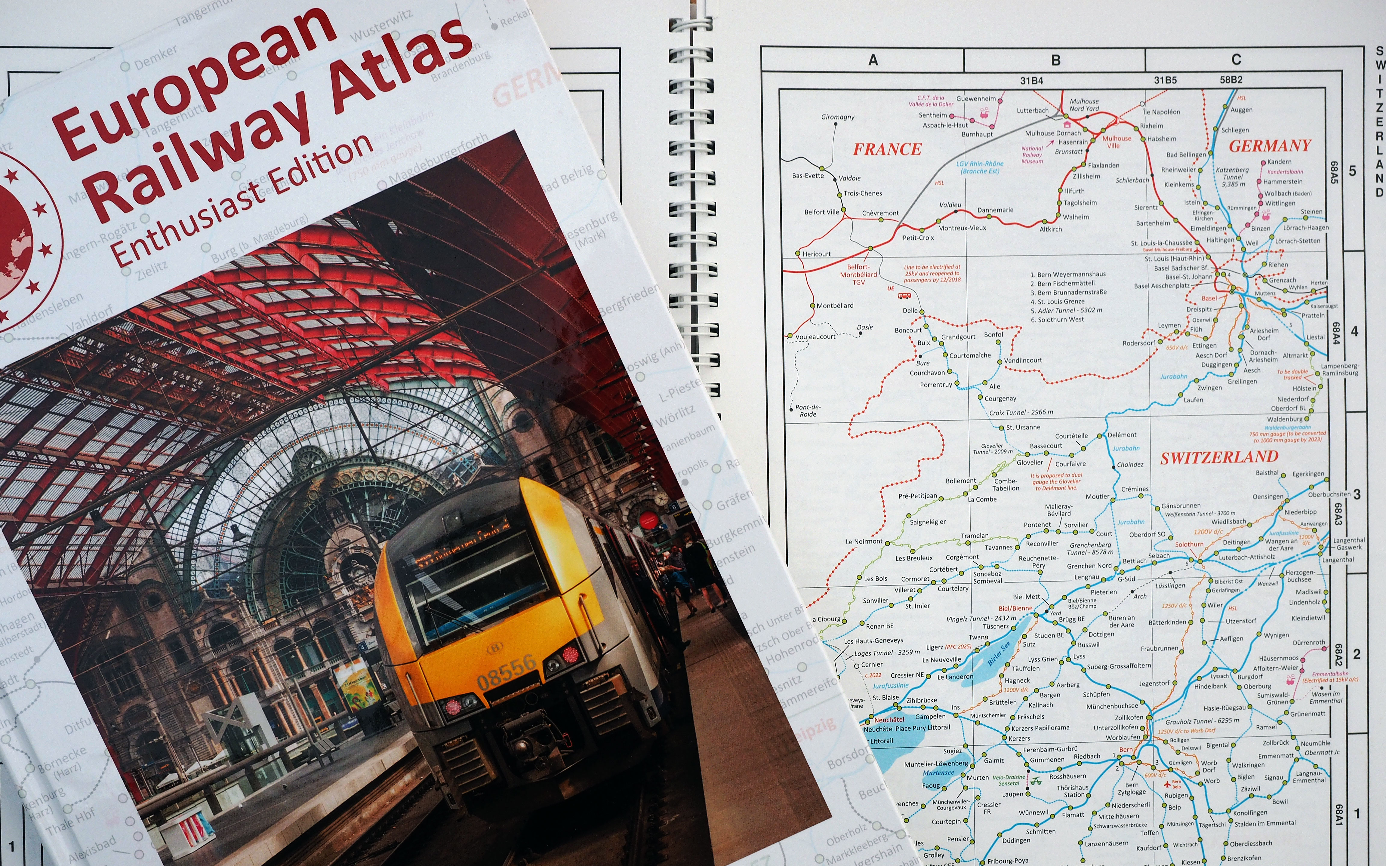
The front cover of the new Enthusiast Edition of the European Railway Atlas. In the background is a sample of the old 2017 edition which was cardback and wiro-bound. The new book is hardback.
Railway cartography is a very specialist area. We are often asked by readers of our Europe by Rail book if there are atlases we can particularly recommend. Of course, you can find basic maps of all 53 routes in the 16th edition of the book here on this website, but we know that many readers are looking for something more.
Our top choice is Mike Ball’s excellent European Railway Atlas (ERA) which comes in various editions. But let’s first take a look at other options.
National atlases for the perfectionist
For those looking for meticulous detail, there are the excellent but very expensive national atlases created over many years by Hans Schweers und Henning Wall. The Cologne-based publisher, named after its founders, is called Schweers + Wall.
A new edition of the Schweers + Wall German atlas was released this month, and we hear that new editions of the Swiss and Austrian atlases are in the pipeline. But some of the other Schweers + Wall atlases are very dated. It’s now over ten years since the last edition of the Italy atlas. The Scheers + Wall atlases typically cost about €30 to €40 each.
A good, basic map
If you are just looking for a perfectly reliable but not especially detailed solution, then the latest edition of the Rail Map Europe, published by European Rail Timetable Ltd, perfectly fits the bill. It’s available as both a flat wall map or in a folded version. The latest version was updated in mid-2019 and is great value, typically retailing in online sales channels for about €12.
The Rail Map Europe comes with an impeccable pedigree, for it is regularly updated by the expert team who compile the monthly European Rail Timetable.
A good compromise: the ERA
Travellers looking for more detail than one might find on the Rail Map Europe might sensibly turn to the wonderful range of atlases published by Mike Ball. These are not works of great cartographic elegance since the focus of the maps is fair and square on the rail routes. Although major lakes are shown, as are national borders, there’s no topographic detail.
But Mike Ball manages to bring together in a single, reasonably priced volume extremely detailed rail maps which cover the greater part of Europe extending from Portugal and Ireland east to the western border of the Russian Federation. There are enlargements of areas with complex rail networks such as major cities and – here’s a surprise – the Donbas area of eastern Ukraine.
Mike Ball produces 14 different regional guides covering different parts of Europe in detail, showing all stations. But we really recommend the Europe-wide atlases, where there is the Tourist Edition and the even more detailed and very chic new Enthusiast Edition. The Tourist Edition is quite basic and only shows passenger lines but is ideal if your interest is planning your journeys rather than technical stuff about the railways themselves. The Enthusiast Edition does just what it sounds like, it gives all sorts of information about track gauges, electrification systems, freight lines, heritage railways and much more.
Mike Ball’s European Railway Atlas (ERA) series is perfect for journey planning, but those with an interest in maps will also find them a wonderfully entertaining diversion. There are plenty of illuminating annotations on the map. Of the line that runs east from Daugavpils in Latvia, we learn that “passenger service is limited to one overnight express.” The reader is also advised that a permanent site for a new railway station in Kiruna (in northern Sweden) is undecided. Over in Donbas, the atlas shows the front line between Ukrainian and separatist forces, noting the interruptions to rail services.
Every product, whether regional or Europe-wide, can be purchased as a printed book, as a digital PDF download or as a bundle with both printed version and the PDF. The top of the range ERA Enthusiast Edition costs about €27 for the printed book, €18 for the PDF or €33 for both together.
You can find out more about the various versions of the European Railway Atlas on its dedicated website where it is also possible to make online purchases.
History of the ERA
The European Railway Atlas has been an incredible labour of love which has been widely applauded in the rail enthusiast community. Mike Ball’s maps are extremely accurate.
Mike Ball tells us that he started what would become the European Railway Atlas in the late 1980s with the first map, covering France & Benelux, being published by Ian Allan in 1990. “Over the next few years I covered the whole of Europe west of the Russian border,” he explains.
“In those days” he says, “the books were all hand drawn on A3 art paper. The indexes had to be hand-sorted on little bits of paper and then carefully typed up, until the advent of the little Psion 3 pocket computer simplified the process.”
But there were challenges. Mike recalls that “trying to accommodate the publisher’s deadlines at the same time as doing my real job as a train driver had turned a hobby into a chore.”
That would probably have been the end of the ERA, but for developments in technology. “Desktop publishing, digital cartography and the internet have changed things,” comments Mike. “These days I no longer drive trains, so with more time I can sit at home drawing the maps on computer, publishing them myself and selling them on my own website.”
Developments in communications have helped too. “Now I am in touch with experts right across Europe who are very kind in feeding information and making suggestions and corrections,” explains Mike. “Without that rich network of contacts, the ERA you see today could not exist. Looking back I can’t imagine how I ever got as far as I did without them! Ultimately, though, I recognize that the ERA is a niche product that’s never going to make a big profit.”
1 Comment
Francesca Whittlestone, 7 December 2020
Can i buy the European Railway Atlas (ERA) asa book ?
thank you
Francesca Whittlestone, 7 December 2020
Can i buy the European Railway Atlas (ERA) asa book ? thank you


About The Authors
Nicky Gardner and Susanne Kries
Nicky and Susanne manage hidden europe, a Berlin-based editorial bureau that supplies text and images to media across Europe. From 2005 to 2023, they were the editors of hidden europe magazine. Nicky and Susanne are dedicated slow travellers and the authors of the book Europe by Rail: The Definitive Guide. The 19th edition of that book will be published in June 2026. Susanne and Nicky also provide consultancy to the rail industry on fares, routes and ticketing. Between them, they know a thing or two about rail APIs.